Sandhill Crane
Latin: Antigone canadensis
A new model for conservation.
Sandhill Cranes Photo: Choktai Leangsuksun
California’s public lands play a vital role in the success and survival of millions of migratory birds. As birds make their perilous journeys across the Pacific Flyway, they need safe and reliable places to rest and eat. These protected lands provide access to food, water, and nesting habitat needed to sustain them along the way.
There are 34 National Wildlife Refuges in California that play a key role in supporting migratory birds. The Sonny Bono Salton Sea National Wildlife Refuge is one of the most important places for birds in North America, offering a rare spot for shorebirds to stop as they travel over large stretches of dry land.
Mono Lake and its surrounding ecosystem provide a diverse landscape, from marsh and meadow to sagebrush steppe and forest. It is ideal habitat for migrating birds, mule deer, and other big game species. In southern California, the Mojave Trails National Preserve and Joshua Tree National Park provide critical habitat for species such as the Burrowing Owl, Red-tailed Hawk, and Prairie Falcon.
So what do these regions have in common? They are all part of a network of large public lands corridors providing essential habitat along migratory flyways. When public lands are well-managed and kept healthy for migratory birds and other wildlife, they provide many benefits for people, such as clean air and water, economic opportunity, recreation, hunting, mental and physical health benefits. Plus, these intact lands buffer against the effects of climate change.
Right now, California is poised to be a national leader in public lands conservation, working at the intersection of climate change, energy production, land management, and wildlife conservation. Visit the StoryMap to see how.
Black-necked Stilt Photo: Logan Southall
Explore our new StoryMap, which identifies key migratory pathways and highlights the most important public lands in California for birds.
California is first in nation to commit to protecting 30% of our lands and waters by 2030.
By partnering with landowners, we can create lasting protections for birds.
Conservation ranching techniques create habitat and sequester carbon. Under a new bill, the state would pay ranchers to implement them.
Vital protections are needed for wetlands that depend on groundwater under the Sustainable Groundwater Management Act
Coalition of conservation and community groups says groundbreaking is positive step towards ending years of inaction at California’s largest lake.
Audubon science finds that two-thirds of North American birds are at risk of extinction from climate change.
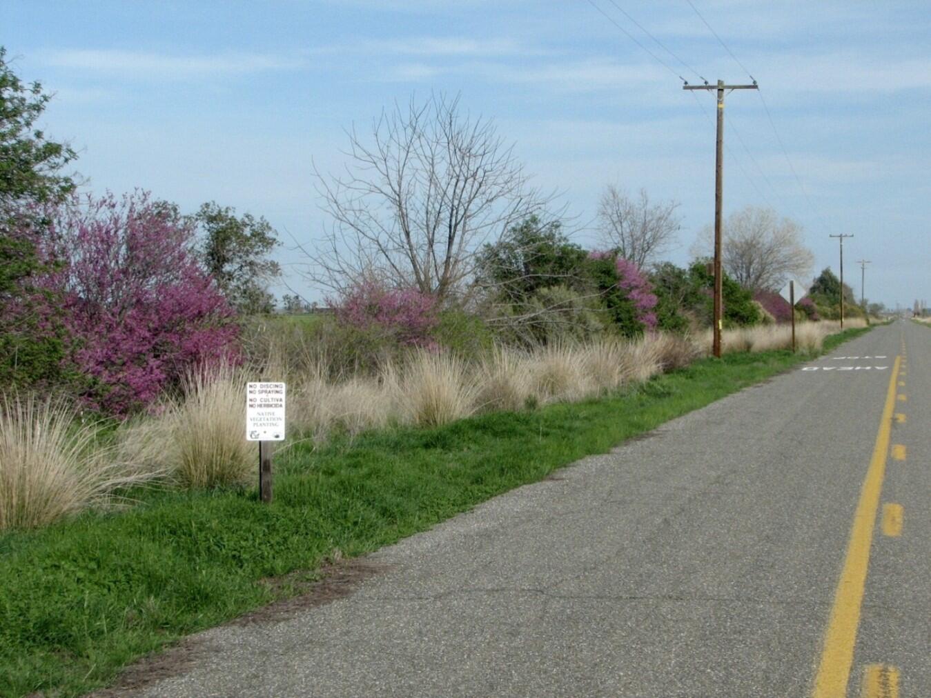
Restoring habitat in a landscape as highly managed as California’s often means working with pieces of land that are marginal – sometimes literally. Continuing a tradition of working with private landowners to restore habitat along farm edges, Audubon is leading a project – together with River Garden Farms, River Partners, the Center for Land Based Learning, Yolo County Resources Conservation District, and US Fish and Wildlife Service -- to install hedgerows along a one and a half mile section of road at River Garden Farms in Yolo County, along a canal near the Sacramento River. This bird-friendly habitat restoration recently installed a carefully designed suite of native plants, such as coyote brush, black willow, and toyon, along two, 1.6-mile-long linear strips along County Road 98A near Knights Landing, California.
While hedgerows provide a number of important benefits to farmers, they can be invaluable to wildlife. They provide cover and food for pollinator insects and birds, riparian habitat when planted alongside streams (or in this case, a canal), and create wildlife corridors between habitat areas. They also prevent the drift of wind-blown pesticides or weed seeds between fields, filter water and reduce erosion. Our hope for this project is to create a habitat connection and wildlife movement corridor between the Sacramento River and the massive area of protected wetlands on Roosevelt Ranch. The overall project intent is to provide enduring wildlife habitat, with a special focus on increasing riparian bird species abundance and diversity while connecting different habitat areas, an important part of making wildlife more resilient in a changing climate.
Despite small breeding colonies in neighboring states, Tricolored Blackbirds are California's blackbird. Over 95 percent of the global population resides in the state. While anyone ever seeing a teeming flock of “trikes” feeding or in flight might have a hard time believing, the bird was listed as threatened under the California Endangered Species Act in 2019. However, Audubon research indicates that populations may be beginning to recover.
As recently as 1930, millions of Tricolored Blackbirds darkened the skies near Central Valley wetlands. As marshes were drained, the birds moved onto agricultural land, especially wheat fields. Farmers typically harvest their crop before nestlings have fledged, even wiping out the young of entire colonies in a single day as harvesting machinery moves across an occupied field. In surveys conducted from 2005 through 2009, less than half of colonies escaped destruction of their nesting areas.
For the past eight years, Audubon has worked together with farmers, the California Department of Fish and Wildlife, Natural Resources Conservation Service and other partner organizations to locate colonies and encourage growers, through financial incentives, to postpone harvests until nestlings had fledged. In a study recently published in the journal Western Field Ornithologists, we found that this public-private partnership has been highly successful: from 2015 to 2022, nearly 100 percent of nesting attempts on agricultural land were conserved, and the number of birds nesting in grain fields increased by as much as 100,000. The reported increase in the population was confirmed during the most recent stateside survey in 2022. This survey is a coordinated voluntary effort, involving many chapter members across the state, to survey suitable habitat areas for birds resulting in a snapshot in time that tells us approximately how many birds are in the population. Protection of the most at-risk nesting sites is contributing to a bump in Tricolored Blackbird populations statewide, but innovative conservation efforts must be continued if the species is to recover fully.
It takes more work than you might think to measure the health of a Long-billed Dowitcher. Not only do you have to be up before dawn, sloshing through muddy rice fields to set up mist nets in the dark, but once the target birds are caught, you have to move fast. You have three minutes to draw a blood sample before stress hormone levels rise, throwing off measurements of their baseline condition.
Prior research suggests Long-billed Dowitcher and other shorebirds are under a lot of stress. According to a landmark 2019 study by the Cornell Lab of Ornithology, shorebird populations have declined steeply over the past 50 years, by more than a third since 1970. Audubon is working with Point Blue Conservation Science and The Nature Conservancy, as part of the Migratory Bird Conservation Partnership to study the impact of years of drought on migratory shorebirds in the Central Valley.
The Central Valley is an ideal place to monitor shorebird populations. This 600-mile-long cleft through California’s center acts as a funnel for a wide range of birds migrating along the Pacific Flyway, including millions of waterfowl and hundreds of thousands of shorebirds, many of which spend the winter in the valley’s temperate climate. This year’s heavy rains notwithstanding, the region has also been hard hit by recent drought, shrinking wetlands at vital wildlife refuges and on private lands. While we don’t know exactly how hard the drought has been on shorebirds, we do know that shorebirds face habitat deficits even in non-drought years, especially in fall and spring, when rice fields and wetlands are largely dry. Audubon works as part of the Migratory Bird Conservation Partnership and many other partners, including the California Department of Fish and Wildlife and the California Rice Commission, to fill this habitat gap facing shorebirds.
While there’s no workaround for predawn hours and muddy slogs through flooded rice fields, newer technology allows us to tag these shorebirds with tiny trackers that communicate with the North American Motus Wildlife Tracking System, a network of receiving towers that get their name from the Latin word for “motion.” This is the same technology that powers Audubon’s Bird Migration Explorer, and it allows us to track where shorebirds are finding habitat… and where they’re not. Another vital piece to understanding drought affects shorebirds is to learn how the birds use existing protected lands at state wildlife areas. In coordination with California Department of Fish and Wildlife staff at state wildlife areas, we are conducting monthly shorebird surveys to understand the contribution of these protected areas to shorebird habitat use.
The study is funded by the California Department of Fish and Wildlife.
Our newsletter is fun way to get our latest stories and important conservation updates from across the state.
Help secure the future for birds at risk from climate change, habitat loss and other threats. Your support will power our science, education, advocacy and on-the-ground conservation efforts.
Join the thousands of Californians that support the proposed Chuckwalla National Monument.